Gold Occurrences in Wyoming

Add caption
Add caption
Add caption
Add caption
1866 Map showing Wyoming in the upper left corner.  South Pass can be found on the Oregon Trail.

One of the most prolific areas for finding gold in Wyoming is around the South Pass area where many gold deposits have been found over the years.  Some of these deposits are measured in the millions of ounces. The state legislature in their infinite wisdom has placed the Carissa Mine with Wyoming’s version of Disneyland so it will never be developed although there is still from $1 to $5 billion worth of potential gold reserves that could be recovered from this deposit during a time of national financial crisis. The mine could also provide hundreds of jobs. Unlike the Abitibi and other greenstone belts in Canada the area around South Pass remains largely unexplored.

Dan Hausel, a geologist has mapped hundreds of gold anomalies over the past thirty years in the South Pass area. The area is a granite-greenstone belt where Hausel mapped over 450 square miles in five field seasons while he was living in a tent. Significant potential is there for iron and gold deposits as well as the possibility of finding colored gems as in the past the area has already produced specimens of aquamarine and diamond.   After bringing fame to the Wyoming Geological Survey Dan retired in 2007, and moved to Arizona.

Oregon Buttes is another area having a huge potential in both paleo-placers and conventional placers.  Geologists consider the buttes to be one of the largest deposits of gold in North America.  The source of all this gold is unknown, but is presumed to be from the South Pass deposits where it was eroded and later deposited at the buttes.

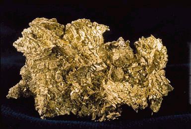
A gold nugget from Williams Creek Wyoming
Photo by Rob Lavinsky


In 1870 the army established Camp Stambaugh near Atlantic City to protect the miners from the Indians, but many of the soldiers deserted to hunt for gold in the area. By 1872 there were twelve stamp mills operation in the area although hostilities drove the miners from the South Pass area until 1882 with the signing of the Treaty of Five Nations. The South Pass area holds many significant hidden and visible gold structures located in a shear zone with the Carissa Mine being the richest.  This is an intensely deformed zone of iron oxides where the primary shear zone ranges from 1.5 to 80 feet wide. The deposit at Carissa is similar in many respects to the Homestake mine in Lead, South Dakota.  There is plenty of geological evidence this shear zone extends to great depths under the Carissa mine. 

Gold was first discovered in Wyoming in 1842 by one of the mountain men working for the American Fur Company, but it wasn’t until 1855 when gold mining started in 1855 when a group of gold miners came to South Pass from the goldfields of California,  Later in 1861 another group of miners commenced mining the placer deposits along Willow Creek. The next discovery was in 1863 when another group of miners discovered the placer gold deposits at the Oregon Buttes.

According to the United States Geological Survey (USGS) Oregon Buttes comprises one of the largest undeveloped gold deposits in the United States.  The gold at the buttes is thought to have its origin in the greenstone belts found at South Pass.

Western Wyoming contains most of the gold deposits in the state although it is likely that some gold can be found in northeastern Wyoming where it joins the Black Hills of South Dakota.

Gold isn’t the only treasure Wyoming holds, some of the finest jade in the world is also found in Wyoming.  The jade occasionally has specks of gold imbedded in the jade making a beautiful specimen. 

The Mali Gold Scam

Native gold   USGS


P. T. Barnum was right there is a sucker born every minute and two to catch them.  I recently received an Email advising me that a gold miner in Mali had 2,500 kg of gold dust that was 96.6% 22k gold.  The price was ridiculous at USD $22,500. This is a good example of the old saying that if it sounds too good to be true it probably is!

How the scam works is by the miner to ask for money to refine the gold dust into bars as it is against Mali law to export gold dust.  Once the perpetrator has your money he vanishes into the woodwork of Mali with your money.

The scam works because there is always an element of greed and cupidity in most people so the best advice is look before you leap!!! 

Gulag Gold

Prisoners working in the Gulag The prisoner who took this photo died short;y afterward.


It was during the 1920s when gold was first found in the Kolyma River Basin by Yury Bilibin a pioneering Soviet geologist.  It was immediately after his discovery that Joseph Stalin founded the infamous prison camps that became the notorious “Gulag” whose purpose was to supply gold to the fledgling Soviet Union.  It was in these camps where criminals and political dissidents were sent to mine gold under the most barbaric conditions.  They were Death Camps where a human life was only worth three weeks of labor and then was discarded.

Prisoners at work mining gold in the Gulag
Yury Bilibin was a young geologist, but already well known in the Soviet Union when he was picked to lead the first expedition into distant reaches of northeastern Russia as head of the First Kolymian Expedition of 1928 - 1929. This was when they discovered extensive deposits of gold that under Joseph Stalin and the Soviet Union were slave labor camps.  It was here that Bilibin developed his theories on placer gold deposits and intrusive volcanics that led to the development of the theory of Metallogeny and Plate Tectonics. In 1938 he published his famous monograph the “Principles of Placer Geology.”  For his work as one of the fathers of this science Bilibin received The Stalin Prize First Degree of the Soviet Union.

For the next 80 years this part of Russia has been extensively explored by geologists who have developed into working mines producing other metals other then gold until today it is a major mining center of Russia. Since the fall of the Soviet Union it has attracted the attention of many American mining companies.

These are the dead in the Gulag.
The Gulag was a system of forced labor camps established by Cheka in 1919 in the Soviet Union, but it wasn’t until the early 1930s that the population of these camps became significant.  By then it was under the control of the Main Directorate of Corrective Labor Camps commonly called the Gulag.  It was no longer operated by the Cheka, but now was under the NKVD, and later the KGB.  All of these organizations were parts of the secret police.  It continued to operate from 1919, but was mainly disbanded after the death of Stalin in 1953.  Parts of the Gulag continued to operate until the days of Gorbachev into the 1990s.  The fall of the Soviet Union in 1991 finally wrote “finish” to the Gulag.

This is one of the gold mining camps in the Gulag.
The prisoners in the Gulag comprised a polyglot group of including murderers, thieves and political and religious dissenters forced to work under barbaric conditions. The Soviets used Gulag Labor for many projects beside mining gold they were also used to build the White Sea – Baltic Canal, the Moscow – Volga canal, the Baikal – Amur main railroad line, a large number of hydroelectric installations, numerous industrial projects in remote areas of the Soviet Union.  It was Gulag manpower that did most of the country’s lumbering and mining for coal, copper and gold. 

Gold was what they mined in the Kolyma Basin, placer gold that was mined by prisoners. A book was published the Gulag Archipelago by Aleksandr Solzhenitsyn a survivor of the camps gives a graphic description of life in the Gulag. Solzhenitsyn was eventually released from the Gulag and exiled from the Soviet Union to settle in the United States where he made his home in Vermont.  The downfall of the Soviet Union saw Solzhenitsyn return to Russia. Today his book, the Gulag Archipelago is required reading in all the schools of Russia as a reminder of what happened in the Gulag.  Not since the days of the Roman Empire had miners labored under such conditions. 

Gold Occurrences in Missouri

The only part of Missouri where gold is found is in the counties bordering the Missouri River where gold was brought down from Canada by the glaciers.  The gold was left behind when the last glacier melted about 12,000 years ago.  Whatever gold is found is extremely, what miners call flour gold that won’t support a commercial operation, but is a lot of fun to find anyways.

This is gold found in terminal moraines that formed where the glacier was continuously melting in one place that are recognized by their hummocky appearance and many sand & gravel deposits. The Gold deposits are often accompanied by diamonds that are more likely to be found in payable amounts throughout the areas where glaciers once trod.  Diamonds are another example of the many riches brought down from Canada by the glaciers.

Gold is found as panable deposits along the sand bars that line the Chariton River and its tributaries.  It has also been found at Kirksville in Adair County in sand and gravel deposits. In Macon County there are two areas containing gold one of these is near the town of Elmer where gold is found in Murray Gulch.  Around the town of Gifford gold has been discovered in glacial deposits.

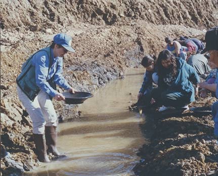
A group being taught how to pan for gold. 
The advice given by many geologists is not to spend too much time looking for gold in Missouri because you will be wasting your time.  That doesn’t mean that Missouri is bereft of minerals because there are mineral deposits scattered throughout the state.  The area around Joplin used to be the scene of extensive deposits of lead and zinc.  These mines are now closed, but there are plenty of mineral specimens to collect in the area.

Gold Occurrences in Arkansas

A view of the Ouachita Mountains from outer space.   NASA 


There is more then gold in Arkansas it also contains the Crater of Diamonds as a state park.  This is found in the Crater of Diamonds state park where the public can find real diamonds in a former diamond mine and are allowed to keep what they find.  This park is just to the south of Murfreesboro.  The state also contains a mineralized area ranging from thirty to forty miles wide and about 150 miles long that offer many chances for the collector to find beautiful quartz crystals.

Quartz crystals from the State of Arkansas
Photo by Rob Lavinsky


Gold in Arkansas was originally discovered by the early Spanish explorers during the 1500s.  Reportedly the Spanish Miners mined gold in the state during their time.  The other time when gold mining occurred was during the period from 1800 to 1830.  Most of the gold in the state exists as small flakes of the type called “pickers” or fine grains.  You can find this gold in the many rivers and creeks draining the central Ouachita Mountains.   This gold is found in roughly the same area where you can find the quartz crystals. The best place to look is in places where there is extensive black staining caused by manganese.  At the time this mining was occurring it was reported they didn’t find much gold.

After the Ouachita Mountains were examined by geologists they came to the conclusion that little gold was to be found in these mountains.  The prospects for placer gold were considered to be better however since gold is weathered from bedrock and is concent-rated into the streambeds as enriched deposits. A similar type of deposit was encountered during the Klondike Goldrush in 1897 where all the gold discovered was in the form of placer deposits that had weathered from the surrounding schist.

Even though gold is scarce in Arkansas doesn’t mean that other mining didn’t occur for many years the state was the largest producer of cadmium in the United States.  This production came from Mississippi type deposits of lead and zinc that were found in the Tri-State Area of Arkansas, Missouri and Arkansas.

In order to make any prospecting venture worthwhile is a real good idea to read everything that you can find about the area where you are going. A good source is your local historical society and library. Among the prospectors of Canada there is a saying that more valuable mines are found in the shadow of a preceding mines headframe.

There are even small deposits of turquoise associated with copper in the Ouachita Mountains. This is then worked sporadically for its value as a gemstone for making jewelry.

Gold Occurrences in Oklahoma

The early Spaniards led by the famous explorer, Coronado thought that Oklahoma was the home of the Seven Cities of Cibola that were legendary places that were made from gold.  It was these rumors that caused another Spanish explorer, Desoto to discover the Mississippi River.  Some of this legend is true since there are two areas on opposite ends of the state where gold is actually found.

The first of these areas is located in the southeastern part of the state in the Ouachita Mountains that are geologically part of the Appalachians that emerge from the surrounding sediments as an extension of those mountains.  Several localities in these mountains have even launched gold rushes in the past.  The gold is found in a continuation of the Southern Gold Belt. These mountains are also related to the Boston Mountains that have generated their own gold rushes.

A painting by Fredric Remington showing Coronado in his search for the Seven Cities of Cibola in  Oklahoma
In the western part of Oklahoma more gold is found in the Wichita Mountains in sandstone that was deposited in the late Precambrian and early Cambrian ages.  Later these mountains became involved in the mid-continental rift that caused the sandstone to become heavily intruded with gabbro.  Even later in their history they were intruded with granite.  And last they were intruded with other volcanic rocks.  These intrusions left behind a legacy of gold. 

Although there is some gold to be found in the Wichita’s there is not much according to reports, but even though there was a gold rush in the late 1800s. This gold rush was stoked by some unscrupulous assayers that kept pumping up the value of the ore that was found. All that is left today are some ghost towns like the Town of Wildman.

If you prospect in either of these districts the best place to look for gold is in the placer deposits of the rivers and creeks that drain down out of the highlands. Modern exploration techniques are apt to discover buried deposits here.

It is more then probable that further exploration of the Wichita Mountains using modern methods of exploration is apt to discover considerable amounts of various metals including gold.
It was the intrusions of gabbro that created the copper-silver deposits of the Keweenah Peninsula far to the north in Upper Michigan that were America’s first large-scale mineral rush.

A similar situation exists in Portugal where Triassic sandstone is heavily intruded by gabbro associated with the break-up of the super continent known as Pangaea. There are gold mines in Portugal operating today that were producing gold and other metals since the days of the Roman Empire.

Rocks associated with the mid-continent rift are especially rich in metal deposits as seen by the copper-silver deposits Michigan. The peninsula was the site of the first mining rush in the US that started in the early 1840s and continued until the mid 1940s it lasted more then a century. Exploration still goes on in rocks of the mid-continental rift. The most notable is occurring in the Arrowhead of Minnesota where they have uncovered massive amounts of copper, silver, gold and platinum group metals in the vicinity of Ely, MN in the Duluth Gabbro.

It is more then probable that further exploration of the Wichita Mountains using modern methods of exploration is apt to discover considerable amounts of various metals including gold.

Gold Occurrences in Texas

A worker in a gold mine


Gold was first discovered by the Spaniards in Texas in 1756 where they discovered gold and silver on Riley Mountain. They made their discovery of gold in the central mineral district around the Llano Uplift. It was in the same area that the Spaniards discovered the lost San Saba Gold Mine that according to tradition was worked by Mexican miners after they gained their independence from Spain sometime in the early 1800s. The Spaniards lacked any technology to keep mines from flooding caused by the inrush of groundwater. This was the reason why the Spaniards limited their mining to those areas that were above the water table causing these mines to exist as long trenches that have long since been eroded away. The consequences of this weathering are that today these old gold mines are hard to find, and for the most part were operated as placer deposits.

The peculiar thing about the Llano Uplift is because it is composed of Grenville aged rocks that are around 1.2 billion years old that are actually an extension of rocks that are often found in the Appalachian Mountains instead of the Rockies. It is in these ancient rocks that gold is found usually in small deposits that are quite numerous; these deposits are similar to those that were found during the Klondike Gold Rush where the gold had eroded from the rocks and formed large placer deposits.

In many of the rivers and streams that drain the Llano Uplift placer gold can still be found. There have been tales of gold occurring in this area for the past 250 years many of these tales are more credible than others. It is tales of this sort to drive the prospecting business even though gold is found in small quantities throughout the area. It is the hope of virtually all prospectors that they will eventually strike a Bonanza or even find El Dorado itself.

The Llano uplift itself is pre-Cambrian in age, but is surrounded by rocks of Paleozoic age making it  very similar to the Gold Belt of the Southeastern United States. Most of The state is an ocean of sedimentary rocks having an occasional outcrop of older crystalline rocks. It is in these rocks that you are apt to find gold. Gold can be found in rocks of both the Proterozoic and Phanerozoic ages.

The rocks found in the hills overlooking Presidio in the Rio Grande Valley are probably closely related in age to the Central Texas Mineral Region. With sedimentary rocks you often find a situation where occasionally older rocks do get exposed at the surface. This was what is happening here as well in the southern gold belt (Piedmont) in the Appalachian Mountains.

On the southern flank of the Chinati Mountains overlooking Presidio is the Prasidio Mine that was active from 1880 until 1942 when the War Production Board closed all the gold mines in the United States to free the gold miners for other wartime production. This one mine produced 92% of the silver and 73% of the gold ever produced in Texas.

There is also gold associated with a sandstone of Eocene age located in the Gulf Coastal Plain. This is gold that probably eroded out of the Llano Uplift rocks.

Nowhere in the state however is gold mining ever been extensive because the amount of metal available in the state appears to be limited. The Presidio and Hazel mines in West Texas and the Heath mine Llano have produced a total of 8,277 ounces of gold that end in 1942 when the government closed on all gold mines in the United States as part of the war effort during World War II. The last minute was in production in Texas was the Presidio mine where production and that in 1942.

Nancy Twinkie Buys a Highbanker

A Jobe highbanker similar to the one Nancy bought.


After she had gone with me on several gold panning trips it became apparent to Nancy
she needed some way to speed up the gold recovery. We already owned a sluicebox,
but Nancy wanted to have something different. It should be pointed out that the Internet
didn’t exist for us common folk in the early 1980s, so Nancy took up reading some back
issues of the Northern Miner that I had, a Canadian publication about the mining scene
that is still published in Toronto.

There was an advertisement for a highbanker in the Northern Miner, so Nancy sent
away for some information about this piece of gear. In essence, a highbanker is nothing
more then a sluice box that stands on stilts, and is on steroids because of the addition of a
grizzly on its business end. Some highbankers also include a pump to supply water to its
sluice. Nancy sent away for the whole works pump and all.

A couple of week’s later Nancy called me to come over to her house as quick as I could
she needed some help. I went right over, and the first inkling I had something was up
was when I saw a trailer truck parked in front of her house. Nancy was there talking
to the truck driver about several large cartons that had to be unloaded containing the
highbanker along with all its attachments including the pump and 200 feet of plastic hose
that was three inches in diameter. It took both the truck driver and me to manhandle
these cartons from the truck, and get then into Nancy’s house.

Then the unpacking began, and the first thing that became apparent was a sign at the
top of the carton advising us that some assembly was required. Now that was a sign I
had seen before much to my regret because in past experiences this had always required
several trips to my local friendly hardware store for missing nuts, bolts and washers. To
my surprise the maker of the highbanker had included all the bells and whistles, so no
trips to the hardware store.

Once the highbanker was set up it proved to be a formidable beast standing on four
metal legs just high enough so you could shovel stream gravel into its grizzly with the
oversized stones falling off the back end. Once the hoses and pump were attached water
went into a manifold below the rear of the grizzly that was distributed in a stream the
width of the highbanker.

Once we had put Nancy’s highbanker together we sat down to read the directions about
how to use the beast. After reading those directions we had to wait for the following
weekend to give it a try.

The Hurdles You Face in opening a New Gold Mine

So, you have been lucky enough to find a good strike of lode gold!

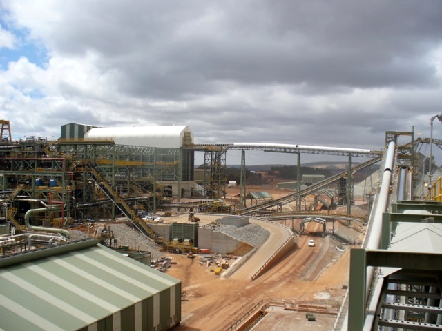
This will give you an idea of the scale of operations found at a working gold mine.  This is the Buddington Gold Mine in Australia.
Photo by Calistemon
That is only the first step in a long journey that is required to change a gold strike into a producing mine. It has been estimated by members of the mining community than in the United States this is a process that can take as long as seven years or more just for getting the necessary permits to mine. There are permits required by several different governmental agencies including the Environmental Protection Agency (EPA) and the Army Corps of Engineers. There are also several other permits that are required at the state and local level that can involve not only the Planning and Zoning Commission (P&Z) in your town, but if you are going to use explosives in your mining operations you are required to have a blasting permit from the town Fire Marshal. In some jurisdictions mining is not permitted under any circumstances.

Even with the permits all in place there is a considerable amount of construction activity that has to be accomplished before you ever get the mine into production. Part of the permitting process also includes a set of plans showing how you were going to open your mine, how work on the mine is going to progress, and how you were going to close the mine. All of this work is expensive at has to be performed by an engineer or landscape architect. It is only providing a basic set of plans that complicates the procedure of opening a mine, it is also some modifications to these plans that are required by several different permitting organizations. Probably the toughest of all is your local planning and zoning commission.

Now that you have your permits all in place after several years then you have to go through the necessary steps required to open your mine, and bring the mind into production. This is going to require all the equipment that is found in a crushed stone quarry and then some. Some of the basic Clement you are going to require is a jaw crusher, a secondary crusher and a set of conveyor belts to move the crushed stone to stockpiles.

A stone crushing plant in operation.
Photo by Richard Law


Depending on the method used to extract gold from its ore will require additional equipment like a giant ball mill to further reduce the ore into a powder. This powder is further refined in a process called floatation where it is mixed with water, and a detergent that forms bubbles that remove the gangue minerals from the gold. These processing steps ultimately lead to a smelter where the gold is cast into bars. The final step of reducing the gold to .999 Fine is done by a special refinery that most miners contract for from an outside source.

A ball mill is the device shown in the background of this photo.


The cost of taking a prospect to a producing mine often exceeds $1 billion or more. That is the reason why only about one in 300 prospects ever get that far, and are developed into a producing nine. For the most part mining lode gold is a major industrial operation that is usually beyond the capabilities of the single person although it has been done in the past and will shortly be done in the future.


Helio Resource Corporation - News Release

Suite 580 – 625 Howe Street
Vancouver, B.C.
Canada V6C 2T6
Toll free: +1 888 955 4728
info@helioresource.com
NEWS RELEASE

Helio Makes a Significant New Gold-Copper-Silver Discovery at the Gold
Kop target, Damara Gold Project, Namibia
50m @ 2.1g/t Au, 0.8% Cu and 14g/t Ag
Includes 7m @ 9g/t Au, 4.4% Cu and 73g/t Ag

Vancouver, June 13, 2011

Helio Resource Corp. (TSX-V: HRC) is very pleased to report the first diamond
drill results from the current drill programme at the Gold Kop Target, on its 100%-
owned Damara Gold Project (DGP) in Namibia.  The Gold Kop Target is situated
45km northeast of AngloGold Ashanti’s  (AGA) Navachab gold mine (see map 1
attached).

Highlights
• 50m grading 2.1g/t Au, 0.8% Cu and 14.0g/t Ag
• Including 7m grading 9.0g/t Au, 4.43% Cu and 73.0g/t Ag
• Multiple mineralised horizons
• Mineralisation outcrops at surface and is open along strike and to
depth
• The intercept is located on the western margin of a 1.2km long IP
anomaly which is open to the north
• The intercept is also located within a 4km-long gold in soil anomaly
which is open to the southwest
• 2 drill rigs (1 diamond and 1 RC) currently active on the Gold Kop
target

These results are from the first hole of an ongoing 5,000m drill programme at the
Gold Kop Target.  OJD1 was drilled to test a large geochemical and geophysical anomaly [see attached maps showing the location of the drill hole in relation to a 4km long gold-in-soil anomaly (Map 2) and a 1.2km long IP geophysical anomaly (Map 3)].  The hole intercepted a number of mineralised horizons, varying from wide zones representing bulk-mineable type targets to narrower high-grade
zones.  A table of the significant intercepts from the hole is presented below.

The Gold – Copper – Silver mineralisation is hosted  by a package of tremolitealtered marbles.  There is a strong association with sulphides, mainly pyrite with chalcopyrite and pyrrhotite.  The highest-grade mineralisation is associated with a zone of fresh massive and semi-massive sulphide and has a Specific Gravity of 4.14.

Drilling to expand and define this large zone of mineralisation is ongoing.
Management believes that this drill hole supports the potential for the Companyto make a significant new gold discovery only 45km away from AngloGoldAshanti’s Navachab mine.

Hole No. From Length
Au
(g/t)
Ag
(g/t)
Cu
(%) SG
OJD1 4 17 0.7 1.9 -
and 51 50 2.1 14.0 0.8 3.24
including 54 7 9.0 73.0 4.43 4.14
and*  129 20.8 0.25 - - 2.90

Historical drilling of Gold Kop
Since the late 1980s, previous explorers have conducted a  limited amount of shallow reconnaissance drilling along  the 4km-long Gold Kop gold-in-soil anomaly.  Drilling results (for which copper-silver values were not reported) from the previous campaigns include:
• 1m at 71g/t Au;
• 7m @ 5.6g/t Au (open);
• 4m @ 8.6 g/t Au (open);
• 8m @ 3.0g/t Au;
• 34m @ 0.9 g/t Au.

Significant drill intercepts (>3m @ >2.0g/t Au) were recorded in AGA drill holes
over a 2.2km strike extent of altered marble and mineralisation is open along strike to the northeast and southwest and to depth.  

The DGP Gold Project:

The DGP comprises four licences  (covering 318,500ha or 3,185km 2), namely
Etjo South, Okakango, Wilhelmstal and Otjimbojo.  Helio holds a 100% interest in
the project through its wholly-owned Namibian subsidiary, BAFEX Exploration
(Pty.) Ltd.

The DGP is located between AGA’s Navachab Mine to the southwest and Auryx
Gold Corp.’s Otjikoto Project to the northeast.The Navachab mine has been in production since 1989 and, as of December 2009, has produced approximately 1.5 Moz of gold and has a non-NI 43-101
compliant resource of 4.48 Moz grading  1.17g/t Au (source AngloGold Ashanti Quarterly Report, December, 2010).

Auryx’s Otjikoto Gold Project, located approximately 150km northeast of Helio’s licences has a NI43-101 indicated resource (February, 2011) of 15.78Mt grading 1.94g/t Au and an inferred resource of 8.37Mt grading 1.94g/t Au for total of 1.5 Moz at a 0.8g/t cut-off. The 5,000m drill programme, which is the first time the Gold Kop anomaly has been systematically drilled, is part of the 10,000m of drilling programme outlined for the DGP in 2011 (see Company’s news release dated January 13, 2011).

About Helio

Helio Resource Corp. is a well financed  gold exploration company focused on increasing the initial NI 43-101 compliant resource  at the SMP Gold Project in Tanzania and outlining the resource potential at the Damara Gold Project in Namibia. In November 2010, Helio released an encouraging initial resource estimate for the SMP: Measured and Indicated Resource of 588,749 ounces (11.82Mt grading 1.54g/t Au) plus an Inferred Resource of 352,354 ounces (9.9Mt grading 1.10g/t Au) at a cut off grade of 0.3g/t Au.

Chris MacKenzie, M.Sc., C.Geol., Helio’s COO and a Qualified Person as designated by NI 43-101, is based in Namibia and supervises the exploration at Helio’s projects, including the sampling  and quality assurance  / quality control (QA-QC) programmes, and has reviewed the contents of this news release.  Hole OJD1 was drilled southwards at -60ยบ.  Intercepts are reported as drilled widths; more drilling is required to determine true widths.  The hole was continuously sampled at 1m intervals.  Samples were split with a core saw and one half was retained on site.  All samples were submitted to the lab with internal QA/QC checks including the use of standards (ave. 1 every 18 samples) and duplicates
(ave. 1 every 25 samples).  Samples were assayed at the Intertek Genalysis Laboratory in Johannesburg, South Africa by 50g fire assay for gold, and by Atomic Absorption for Copper and Silver.  As well as the Company’s internal QA/QC programme, Intertek  Genalysis also applied their own internal QA/QC
programme, consisting of insertion of standards and duplicates.  Weighted average intercepts are calculated using a  0.5g/t Au cut-off (except for the zone from 129m, which has a 0.2g/t Au cut-off) and may include some mineralised waste.   Highest individual 1m assays were  18.1g/t Au from 54m, 5.6% Cu from 57m and 99.0g/t Ag from 58m.

For additional information, please contact Richard Williams or Irene Dorsman at +1 604 638 8007 or by e-mail to richard@helioresource.com or irene@helioresource.com.
ON BEHALF OF THE BOARD OF DIRECTORS
“Richard D. Williams”    “Chris MacKenzie”
Richard D. Williams, P.Geo  Christopher J. MacKenzie, C.Geol. CEO            COO

Neither the TSX Venture Exchange nor its Regulation Services Provider (as that term is defined in the
policies of the TSX Venture Exchange) accepts responsibility for the adequacy or accuracy of this release MAP 1   Location of Gold Kop Target, centrally located within Helio’s Otjimbojo LicenceMAP 2   Location of hole OJD1 in relation to Geochemical Anomaly (backdrop is of aster image mapping out carbonate horizons, historical drill intercepts also shown).MAP 3   Location of hole OJD1 in relation to IP Anomaly.

Gold Occurrences in New Mexico

A copper mine in El Chino that produces gold as a byproduct.
Photo by Eric Guinther


New Mexico may be billed as the Land of Enchantment, but it is also known for its gold deposits as well as other minerals. These gold deposits generally follow along the crest of the Sangre di Cristo and other mountain ranges of the Rocky Mountains. This gold bearing belt cuts across the center of the state from the Colorado border south to the Mexican border. In this area it is possible to find both placer and lode gold. In much of this area gold is produced as a byproduct of mining other metals particularly copper.

Gold was originally discovered in New Mexico by the Spaniards in 1828, but there is evidence that the Native Americans they have found the gold deposits even earlier. This goal is mainly contained in a gold belt that cuts diagonally across the state from northeast to southwest that ranges from 50 to 100 miles wide. The gold and other metal deposits are closely associated with volcanic rocks found in the same area that can range from quartz monzonite to granodiorite intrusives. Most of these volcanics were produced during the Cretaceous or tertiery times.

There is a fine brochure produced by the New Mexico Bureau of mines and mineral resources that outlines the process of prospecting for gold for both amateur and professional prospectors. Many of the principles of prospecting can be used in other places as well as New Mexico.

There is no longer history of mining in New Mexico a place that had many good mines in the past, but today most of the gold produced in New Mexico is a byproduct of the copper mining industry.

The state also contains extensive placer deposits that have been washed down the mountains in dry washes and streams whenever a flash flood strikes. One authority states that the placer gold found that New Mexico has hardly been scratched because it is so dry that conventional panning methods don't work. To compound this does so-called dry panning methods don't work either because throughout the area the matrix containing the gold is damp and doesn't take kindly to conventional mining methods. Another factor limiting the hunt for placer gold is a layer of concrete subsoil called caliche but also limits the production of gold.

To find placer gold it is best to hunt in areas that have already produced gold. One of the places of interest is where deposits of gravel have come down from the mountains in arroyos, but these he posits are often naturally cemented together forming a stone like deposit that has to be treated like hard rock. Also the placer gold state is found between 3000 and 8000 feet. The higher elevations of least produce enough water for conventional placer mining.

A simple test for gold

Hydrochloric acid is sometimes called muriatic acid when it is in dilute form.  The dilute acid can be used as a simple test for gold.
Sometimes it is a case of not being able to see the forest for the trees, and sometimes I am guilty of this fault among the many others I have. Gold is not called the noble metal because it is used to make crowns, but because there are very few things that can cause it to dissolve. Aqua regia, a mixture of one part of nitric acid and three parts of hydrochloric acid is one of them. It can also be dissolved in a solution sodium cyanide, and a few other compounds.

There are very few minerals that resemble gold alone and a few sulfides that are commonly called fools gold. Some weathered mica can also resemble gold if these substances are treated with acid they will dissolve and emit an odor like rotten eggs. You can use ordinary vinegar to make this test if you want, but muriatic acid works even better. You can buy this acid at a local mason supply store or some times at your local hardware store. Another source of acid can be found in your local auto parts store under the name “battery acid.Battery acid is a dilute form of sulfuric acid, but any of them will work for this test.

If the material forms than crystals, and it is the color of gold is most probably fools gold. When acid is supplied to this material it will make a gas called hydrogen sulfide is smells just like rotten eggs, you can't miss it. Gold is not affected by any of these acids, nor does it create a smell. This is not to be considered a definitive test for gold, but it sure eliminates in a real hurry many things that do look like gold.

Weathered mica is one of the few things that may not eliminate, but the reaction when acid may bleach the iron staining that makes it look like gold. In any event weathered mica is about nine times lighter than real gold. The only other metals that are not affected by acid are the platinum group metals because they are also considered to be noble metals.

Gold and platinum are often found together so much so that the early Spanish Conquistadors in Peru used platinum as an alloy in their coinage because they had no value for platinum. During the 20th century many of the Spanish coins were dissolve so their platinum content could be recovered.

This test can be used on both gold that is visible to the naked eye, and gold that is only visible under a microscope. It is best to draw a circle around microscopic specimens with a pencil so you can find them again. The graphite in a pencil is not affected by any acid, but don't use a ballpoint pen because the eight may be affected by the acid.

Something else that can be added to your prospecting equipment is a dropper bottle for holding the acid allowing you to dispense it one drop at a time. For many tests all you do this a single drop of acid. This test is also useful for finding out if a stone as limestone or not. In the presence of calcium carbonate it fizzes.  It doesn't affect Quartz, but gold is often found in either mineral. Occasionally it is also found in Jade as flecks of gold.