The Abitibi Gold Province of Eastern Canada

During the course of writing the articles about the states in the American Midwest where gold occurrences are we made several references to the Abitibi Gold Belt in Canada located in the provinces of Québec and Ontario. This is what the Abitibi is about.

The Dome Mine in Timmins, Ontario one of the original gold mines of the Porcupine Gold Rush

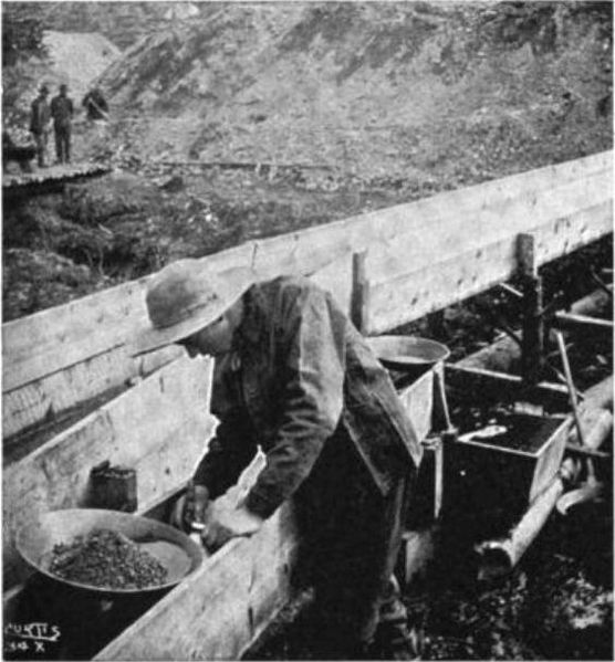
We are taught about the great gold rushes that occurred in the Western United States during the latter part of the 19th century, but we know very little about the biggest Goldrush that ever occurred in North America. Know was that the California gold rush, nor was it the Klondike Gold Rush it was the Porcupine Goldrush that occurred about 600 miles north of New York City in Porcupine, Ontario. 

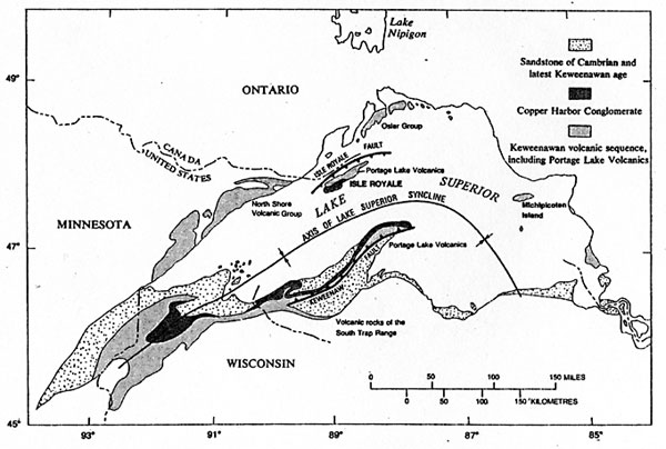
This Goldrush occurred in the Abitibi Gold belt that has proved to be one of the great gold bearing provinces on earth, and appears to be exceeded in size only by the Witwatersrand of South Africa.  The Abitibi is a continuous band of gneiss, granite and greenstone extending from Wawa, Ontario to Val d’Or, Québec that is the same goes is produced more gold than there is in Fort Knox. Since 1901 the gold mines of the Abitibi region of produced more than 170,000,000 ounces of gold; more than 68,000,000 ounces of them produced in the Township of Timmins, Ontario alone.

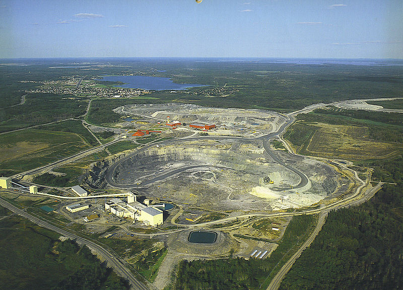
The Kidd Creek Mine in Timmins Ontario a leading producer of copper and zinc.  NOAA

During its history of his loss of more than 100 years they have a time he gold belt has produced over 100 gold mines, and from recent exploration it appears that the Abitibi is going to produce even more gold than it has in the past. Gold is not the only metal that is produced in the Abitibi Gold belt it has also been the scene of some very large base metal mines. It is in the same town of Timmins that the fabulous Kidd Creek Mine is located that kicked off a mining rush in early 1964 that today is producing copper and zinc along with other metals at a depth around 9500 feet making it one of the deepest mines in North America. It also produced the base metal mines around Rouyn-Noranda said gave birth to the Noranda Mining Company that during its day was one of the largest mining companies in the world.

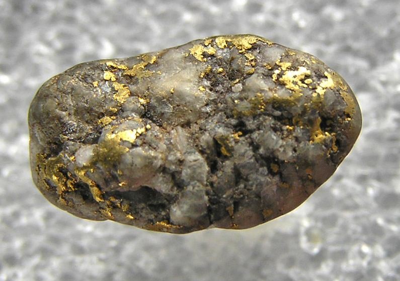
Aside from its production of over 170,000,000 ounces of gold the Abitibi has also produced 35,000,000,000 pounds of zinc, 15,000,000,000 pounds of copper and 400,000,000 ounces of silver. In addition there are several minor metals that are also produced like germanium and indium. Even today they keep finding more mineral deposits in the Abitibi.


.

On the Nature of Placer Gold

Gold is found in all the rivers of the world in sizes ranging from nuggets that can weigh several pounds to tiny flakes that are the size of a grain of flour. There is a size range between nuggets and flour gold that are called “pickers” because they can be picked up between the thumb and forefinger.

Although placer gold forms as particles weathered from existing bedrock that are concentrated into viable deposits by the action of running water in rivers or beaches, or by wind. In rivers gold is commonly found in places where there is a sudden decrease in the velocity of water causing the gold to fall out of the current. Gold has a specific gravity slightly higher than 19 when it is pure. It is this high specific gravity that causes gold to be carried down through a layer of sand and gravel to come to rest on the surface of the bedrock under the river. It is because of this fact that gold is rarely visible in a river. Gold is also found in aeolian deposits where the wind has blown away for lighter components of sand.

This is gold dredge No. 3 in Nome, Alaska the largest dredge in the world for mining placer gold.

Another type of placer deposit is formed in areas that have not been glaciated that are called saprolites. These deposits can be several hundred feet deep, and are composed of bedrock that has been subjected to a warm moist climate that has changed the rock into a mixture of clay and quartz leaving behind gold and a host of other insoluble minerals. In this case the gold is scattered throughout the entire depth of the deposit.

In all placer deposits gold is mostly found in the sand portion of the deposit gold nuggets are found in the gravel portion. Before the invention of metal detectors a great deal of gold was lost in the tailings pile because the miners classified the material they were working into sand. The gold nuggets were often discarded with the mine tailings, but are now being recovered by modern miners equipped with metal detectors.

Placer gold in a gold pan.
By alaskagold 
Although it is usually possible to recognize gold in placer deposits by its color. There are times when there is a thin film of metal oxide; usually iron or manganese that forms on its surface. Gold then takes on the appearance of the other black sands in the gold pan making it virtually impossible to recognize. This problem can be solved by treating the concentrate with vinegar or muriatic acid that dissolves the covering of metal oxides.

An old time prospector panning for gold.
By Tony Oliver

There is another type of gold that we are all familiar with these are the tiny specks that show up when we are finishing a pan of gold. These specks are so small that they float on the surface of water by surface tension and are called "floaters" by prospectors.  We normally lose them over the edge of the gold pan. This can be prevented by a single drop of dishwashing detergent added to the pan that causes these tiny specks to sink to the bottom where they can be recovered in the course of a regular cleanup.

Gold Occurrences in Minnesota

Making sense of the geology of Minnesota requires that you also consider that of Ontario to the North bordering Minnesota.  Looking at the western end of the Abitibi Gold Province located in Wawa, Ontario from the air you see a series of fault lines can be distinguished that from the air that appear to dive under Lake Superior. 

Geology of the Lake Superior region.  USGS

The question to be answered is the Vermilion Greenstone Belt that lies to the east of Lake Vermilion a western extension of the Abitibi Province.  The Vermilion Greenstone Belt is within the age range of the Abitibi at about 2.7 billion years old.  

Starting in the early 1990s a drilling program was undertaken that suggests that this may be the case. In the past twenty years finding gold in Minnesota has drastically changed not only by the findings in the Vermilion Greenstone Belt, but also by the findings associated with the Duluth Gabbro in the Ely district of the Arrowhead of Minnesota.  There have been millions of ounces of gold that are associated with the volcanogenic massive sulfides that have been discovered there by Duluth Metals and other mining companies.

Prospecting for gold in Minnesota goes back to the 19th century when some of the 49ers returned from the California Goldrush.  It was some of the early gold prospectors that discovered the Mesabi Range while searching for gold.

Gold in quartz typically lode gold.
Photo by Rob Lavinsky

Like all the other Midwestern States the glaciers have brought down gold from the gold regions of Manitoba and OntarioPlacer Gold is found throughout the state with the best prospecting is in the rivers and streams. Another place where placer gold may be found is along the shores of Lake Superior. There is an active gold prospecting community located in Minnesota. This is not counting the lode gold deposits.

Gold in Glacial Outwash Plains

When a glacier melts there are large quantities of water that flows off its edge carrying large amounts of glacial debris that is deposited in front of the glacier.  The action of the rushing waters is characterized by being flat layers of sand and gravel or in some cases finer materials. This is called a "glacial outwash plain."

Glacial meltwater flowing from beneath a glacier.  Note the milky appearance of the water.
Photo by Siri Spjelkavik 

Another characteristic of outwash plains is the abundance of braided stream channels that are found in areas of a high concentration of sediments and running water.  This is a perfect environment for gold deposits to form wherever these is a sudden change in water velocity from fast to slow.

This glacial meltwater eventually flows off into the sea. If the land slopes up in front of the glacier it can form large glacial lakes of glacial melt water at the margin of the glacier.

Water flowing into these glacial lakes from gullies across the ice often form upraised deltas in the lake consisting of mostly sand and gravel. The bottom of the glacial Lake away from the delta deposits is covered with a layer of clay that forms a flat surface like a tabletop.

A glacial outwash plain, and how it is formed
After msu.edu 

The glacial melt water flowing across the glacier is so charged with suspended particles like silt and clay that it appears milky. This is called glacial milk that can be seen wherever glacial melt water is flowing off, or under a glacier.

Glacial outwash plains are recognized by their special kinds of agriculture that favors plants that grow best in a well drained soil. The most common crops found in one of these areas are potatoes.

Because these areas are usually well drained the glacial melt water has long since vanished, and it is difficult to recognize the drainage patterns of a braided stream channel as they now exist. One of the best methods of finding one of these ancient stream channels is by observing the amount of gravel that is present, and how it is deposited.

A stream channel can be recognized as an area containing abundant gravel. These ancient stream channels can often be seen when excavation exposes them to view. This is the most likely place to find gold in the glacial outwash plain.

Learn how to Prospect for Gold

Panning for Gold


We are going to teach a class on prospecting for placer and lode gold at the Log House Restaurant on US Route 44 in Barkhamsted, Connecticut on May 21, 2011 starting at 9:00 AM and lasting until 3:00 PM.  This class will give you information about both placer and lode gold prospecting methods.  Emphasis will be on placer gold although a great deal of information will also be taught concerning lode gold in NW Connecticut that has some of the most complicated geology in the world.

In addition to the classroom studies we will spend part of our time in the field examining some of the situations and places where gold can be found.  We will also teach you some of the tricks of the trade. 

Each participant in the class will receive a Garrett Gravity Trap Gold Panning Kit, Model #1651-300 as part of his tuition fee.  This is a $29.95 value.

Please make all checks payable to John Carter.  Payments can be made by check or money order or by credit card via PayPal at: geotekllc@gmail.com 

Address:

John Carter
11 Meeting House Rd.
Suite 21a
Barkhamsted, CT 06063
Tel:  860-469-4804
Cell: 860-605-0475

About your instructor:

John Carter has been an avid prospector since childhood having prospected extensively in the gold bearing areas of Canada notably in the Abitibi Gold Province of Quebec and Ontario.  He also has prospected for placer deposits throughout New England and Maritime Canada.  John holds a degree in geology and has been a guest lecturer at the New School in New York, and Northwestern Connecticut Community College in Winsted, CT.  John has also been an army drill sergeant, so watch your step or he will write your name down.  He underwent 8 levels of instruction in the Army Instructors School, and is rated an expert in instruction. 

About the area:

Northwestern Connecticut contains some of the most complicated geology in the world, and although the gold deposits are sparse they are enough for you too see what gold looks like.  The paucity of placer deposits in the area may have been caused by the last period of glaciation having swept most of the potential gold and carried it further south to Long Island.  There has been at least one gold rush in East Litchfield when they were building the railroad bridge across Spruce Brook in 1849.  We had our own 49ers, but gold has also been found in Leadmine Brook in Thomaston, and along the Naugatuck River from Winchester South.  Gold is also found in the Farmington and Housatonic Rivers and their tributaries. 

Lode gold in the area:

Lode gold has also been found in the general area of Northwestern Connecticut by John Carter in East Litchfield during the construction of Rt. 8.  The fact that there are few reports of lode gold here is more apt to be related to lack of looking rather then lack of gold. Finding lode gold is much more difficult then finding placer gold.

Registration Form

Cutoff Here

Name: ________________________________

Address 1: _____________________________

Address 2. _____________________________

City: __________________________________

State: ___________ Zip: ___________

Tel: _________________

E-mail: _________________________

Please enclose registration fee or E-mail registration form to geotekllc@gmail.com

Gold Occurrences in Wisconsin

There is gold to be found in Wisconsin in the forms of placer deposits in just about any county in the state that were brought here by the many glaciers that have come down from the gold bearing regions of Canada. It should be remembered by prospectors that Wisconsin is divided geologically into two different parts that are nearly equal in size. In the southern part of Wisconsin the basement rocks are buried under a deep deposit of sedimentary rocks that in some places can be miles deep. The northern part of the state is a continuation of the Canadian Shield.

Bedrock map of the Lake Superior region.

Gold found in the northern part of Wisconsin comes from both small lode deposits as well as widespread placer deposits. The placer gold is found in just about any stream or river in the state as well as the beaches along the southern shores of Lake Superior. The deposits lode gold all discovered in several places up to this point none of them found were economically viable. There are several mines in the northern part of the state that are producing both iron and other base metals. Geologically there is no reason why gold should not be associated with these deposits. Just across the border in Michigan there is working gold mining that is produced gold for many years. Of interest are the copper mines that are found in the northern part of the state where the operators of these mines were well aware of the presence of gold, but for economic reasons they just didn't raise the issue.

Throughout the whole state of Wisconsin there are glacial deposits of placer gold brought down from Canada that by being reworked by running water for placer deposits. These deposits are found in the rivers and streams wherever there is a sudden change of velocity in the running water, or on beaches of the many lakes in the state where the gold is concentrated by wave action. Gold of this nature is usually found in fine grains and what is termed flour gold that forces the prospector to become very skillful in the use of the gold pan recover this gold.

Glacial Deposits
Photo by Richard Webb

The gold isn't the only thing the glaciers brought down from Canada; they also brought down several gemstones including diamond, ruby, sapphire and zircon. Weight for weight the stones are actually worth more than gold with the exception of zircon. Deposits of these gemstones are often found in placer gold deposits because there are also concentrated by the action of flowing water. Like gold the glaciers scattered these gemstones across the whole state.

A glacier.
Photo by Kristan Hutchison

Anyone in Wisconsin is allowed to do what is termed recreational gold panning without having to have a license as long as the stream banks and bottoms are not harmed or large amounts of silt and other waste products is not released into the waters of the State. Any gold you find belongs to the person that holds the mineral rights on the property where you found it. You must get permission from the property owner before you do any panning by reaching some sort of agreement with the holder of any mineral rights before you start gold recovery. 

Gold Occurrences in Michigan

Michigan is divided into two parts that have entirely different geology; Lower Michigan is covered by a thick layer of sedimentary rocks were the only gold and is to be found is placer gold. Just about any river or stream in the lower part of Michigan can carry placer gold as well as the beaches of the Great Lakes and other lakes found throughout the state.

A gold pan containing gravel.

Photo by Nate Cull

Upper Michigan is quite different from the other part of the state geologically, and is more in tune with the geology from further north in Canada as a part of the superior province of the Canadian Shield. Most of the placer gold that is found in Michigan had its origin in the Abitibi region of Canada that reaches from Wawa, Ontario to Val D’or, Québec. This is a green stone built that extends for more than 500 km across Canada does little are just gold producing areas on earth having produced since its discovery in 1909 more than 160,000,000 ounces of gold.

Although there is no lode gold in the lower part of the state that isn't true of Upper Michigan that is had several producing lode gold mines. Gold was also been produced as a byproduct from the vast copper mines in the Keweenaw Peninsula. The same mines also produced a considerable amount of native silver that many times was combined with native copper in a product that was known to be early miners as a “bicolor.”

Although gold panning can be done in just about any part of the state one of the better places to find gold is on the shores of Lake Superior where you can find gold in the beach sands. Most of the gold is found in the black sands of your sometimes exposed as stripes along the shore. Because of the way gold was brought into Michigan by the action of glaciers the probability of finding Gold along any of the Great Lakes shores should be considered.

There were a number of hard rock prospects and even some paying gold mines that were found in Marquette County in Lower Michigan. The most famous of these mines was the so-called "Ropes Gold Mine" that operated from 1881 until 1980 that only closed by an underground cave-in causeing so much damage that the mine could no longer be worked at a profit.

A gold prospector at work. 

Many of the prospects of both placer and lode gold deposits were scams. In many cases the property was salted with gold to make it look like a good investment to get money from suckers. There were other mines that operated that were bona-fide gold mines. You might not get rich mining gold in Michigan, but there is always a chance that you will.

Gold Occurrences in Illinois

You might not exactly figure that you could find gold on the waterfront of Chicago or along the many beaches that are found on the shores of Lake Michigan, but that may be a very likely place to look. The USGS reports that there is no minable gold from Illinois even though the same glaciers that brought gold down from the Abitibi region in Canada no doubt affected the state of Illinois to as far south as the Ohio River. There are some old reports that mention lode gold being found in the state that might be credible.

Gold panning in a small stream.
Photo by Sylvia Duckworth


There are some reports mentioning that there was a small amount of gold found from quartz geodes that were discovered while digging a shaft in the dolomite of Stephenson County. This is located in the upper Mississippi Valley lead and zinc mining area. There were also reports into Peoria Star-Journal that are dated August 6, 1975 that a small amount of gold was recovered from a mine shaft dug in Bald Knob a large hill in Union County.

Mostly gold found in Illinois came from the Abitibi Gold Belt and to the north in Canada. This gold bearing region extends from Wawa, Ontario to Val D’or, Québec and is one of the largest gold bearing regions on earth that since gold was originally discovered in 1909 has produced over 160,000,000 ounces of gold. This not only brought down into Illinois placer gold that is found in the rivers and streams throughout the state, but also there are reports of boulders containing gold that is said to be 
worth as much as $25 per ton.

A $20 gold piece known as a Gold Eagle.


Placer gold has been reported from several localities in Illinois including:
1. The Sangamon River Valley in Macon County,
2. The Mississippi River Valley and a small tributary in Henderson County,
3. The Illinois River Valley in Fulton County,
4. The Spoon River Valley in Fulton County,
5. An outwash plain in McHenry County.
Most of gold found in Illinois is from the northern part of the state including Chicago where most of it is concentrated in the so-called terminal moraines that were left by the glaciers and are recognized by their stomach he appearance. The gold found their death and rebirth and concentrated by the action of flowing water in the rivers and streams that are found in that part of the state. The gold is found is usually just a few flakes or gold dust that are found in the sand and gravel deposits usually in the bed of a stream or river.

With this kind of gold deposits anyone processing a very large amount of sand and gravel may find that recovering gold can be profitable. This is not a job for a single prospector although he can usually find enough gold to show other people what it looks like, and have some bragging rights.

The operators of sand & gravel pits are in a different situation because they are processing large amounts of sand and gravel every day. They could include a sluice box in their processing spread to concentrate gold from sand. If they are washing sand in their normal course of processing they could very easily place a gold trap in their spreads. A feature of placer mining of this type depends on the fact that most placer gold that is found in Illinois occurs in the sand portion of aggregates. This eliminates the need for processing the gravel portion of the product.

Gold is not the only thing that the glaciers brought down from Canada also brought diamonds, rubies, sapphires and zircons. These gems have been found as reported in “Canadian Diamonds,” a special report published during the summer of 2008 by the Northern Miner. Some of these diamond deposits are found in classical kimberlite deposits. Other occurrences are found in ancient gravel deposits that have solidified as conglomerate. The final source is alluvial diamonds and other gems brought down from Canada by the glacier..

Gold Occurrences in Indiana

A glacier like this once covered Indiana to a depth of over two miles.
This glacier melted away only 12,000 years ago bringing with it gold and precious stones from Canada.

The entire state of Indiana is covered by a layer of glacial drift that was deposited during two episodes of glaciation that occurred in the last 300,000 years. These were the Illinoian and Wisconsinan glaciers that deposited gold bearing glacial deposits of sand and gravel across Indiana all the way from Lake Erie to the Ohio River. That wasn't all the glaciers brought with them to place your deposits of Indiana also carried diamonds, rubies, sapphires and zircons. 


It was reported by one writer does the gold in Indiana came from an unknown source, and covered most of the state. The gold is found throughout Indiana came from the Abitibi Gold Province of Canada that extends all the way from Wawa, Ontario on the shores of Lake Superior to the Val D’or, Québec the distance of over 500 km. The Abitibi is the second most rich gold producing area in the world after the Witwatersrand in South Africa. Since the initial discovery of gold in this region in the early days of the 20th century the gold mines of the Abitibi have produced over 160,000,000 ounces of gold. This is more gold than there is in Fort Knox!

Panning for gold
Photo by Alan Souter

It was from this region that the glaciers scraped off all the loose gold in deposited it in the states of the American Midwest. You can readily see this just by looking at a map of North America, Indiana is due South of Canada.

Rather than going through a long tiresome list of gold producing streams and rivers in Indiana is simpler to just say that gold can be found in any one of them, as wells as any sand and gravel deposits that are found in the state.

All the gold deposits that are found in Indiana are placer deposits with no lode deposits in the state at all. This is because the state is covered by a thick layer of sedimentary rock that was deposited during the Paleozoic era over 200 million years ago. The layer is several thousand feet thick, and any lode gold would be discovered in the crystalline rocks that underlay the state. These rocks are the same variety found in Canada, so they probably contain gold deposits that are out of reach at the present time.

A great deal of information concerning gold and other mineral deposits in Indiana are available from the USGS, and the Indiana Geological Survey.

Gold of a Different Color

Everyone knows that pure gold is the color of the early morning sun, a great golden yellow, but one gold is pure it is too soft to be worn or have any other useful purpose other than its intrinsic value. Not all gold is golden yellow because when it is alloyed it is possible for the metal to assume different colors. The effective changing of the color of gold has been known to goldsmiths for thousands of years to create many of the effects that are seen in gold jewelry. This effect is produced by alloying gold with other base metals.

This is a phase diagram illustrating the various colors of gold alloys.
Image by Metallos

One of the most common ways that the color changes and gold are observed is when different alloys are combined as inlays in jewelry where the lighter color of a particular alloy is used in conjunction with a darker colored alloy.

Although most interesting varieties of jewelry made this way is what is termed Black Hills Gold. Most of the jewelry made from this kind of gold is 10 to 12 caret is carefully alloyed with other metals to create the colors.

A Tibetan gold statue from Mustang made from an alloy of gold and copper. 

Pink or rose gold is created by alloying copper with the gold causing it to acquire a pinkish or rose-colored caste. Another common alloy of gold creates a greenish caste by making an alloy containing silver.

Metallurgists will find them there recipes for different colors of gold. There is even a purple colored gold that is produced by alloying gold and aluminum.

Prospecting for Gold in Larger Mature Rivers

A mature river is characterized by a slow flowing current with lots of meanders flowing across a relatively flat plain where the grinding action of the stream load will tend to grind any Gold present into fine particles like flour that are very difficult to recover. Because of this many of the larger streams are overlooked as places where you can find placer gold. However, there are a few places in one of these rivers that might be a profitable place to look.

This is an example of a mature river in Germany, The River Saar.
Photo by Wolfgang Staudt

For the purpose of this discussion we are going to use the upper reaches of the Connecticut River between Vermont and New Hampshire as an example, but the same situation occurs in all large rivers that are located in gold bearing areas.

This is a typical gold bearing stream, Walton Creek in Southeastern Idaho.
Photo by Finetooth 

The first situation occurs at the mouth of a gold bearing stream where it enters the larger river. Since for the most part gold is found along the banks of streams and the edge of water because of its great density it does not like to migrate downstream except under the influence of some fast flowing water that is usually represented by a flash flood or spring freshet. In the case of its entering a larger river there is a sudden drop in the velocity of the current at the mouth of the stream that will cause gold to be deposited at the mouth of the stream and along the water's edge in the larger river.

This is a Spring Freshet on a river in New Brunswick, Canada

The other situation where gold was found is that the larger river encounters a waterfall where the gold in the river is set to be deposited in either the cracks and crevices of the rock that forms the waterfall, or in the plunge pool beneath the falls.

This is a small waterfall flowing over ledge; the cracks and crevices in the rock would be one of the best places to look for gold because it forms a natural trap for gold.  The plunge pool at the bottom of the falls would also be another place to look for gold as all the gold coming down the stream would tend to collect there.
Photo by Liam Higgins

It should be remembered that most gold is transported along a stream by the action of episodes of flash flooding rather than the slower moving currents that are encountered during the summer. This is true of all rivers or streams.

The final place where it might be profitable to search for Gold in a large river is where a floating tree or other debris forms a natural riffle in the bed of the river.

Although you can test for the content of gold with a simple gold pan, but for more serious mining you should use some variation of a sluice box for maximum gold recovery. One of the more effective of these devices is the recently invented GoldCube.

Recovering Gold with a Sluice Box

One of the oldest methods of recovering gold from stream gravel is the sluice box that has been around for thousands of years. All a sluice box is literally a box that is open on both ends and does not have a top. Other than the gold pan the sluice box and its variations are still used today for the recovery of gold in both small-scale and large-scale placer mining.

Removing gold from a sluice box

All sluice boxes are lined with riffles designed for the recovery of gold that usually take two parts. On the bottom of the sleuth box is covered with some sort of fabric usually indoor/outdoor carpeting, or another effect of gold trap is the backside of a strip of conveyor belt. The riffles in a sluice box represent obstructions in a flowing stream of water that mimic naturally occurring obstructions found in a streambed.

Sluice boxes come in all sizes ranging from a 3 foot aluminum version that is portable enough to be handcarried to the stream where you are going to work. The other extreme is found at work in many commercial gold mining projects all over the world. Most of these sluice boxes are built from wood where they are going to be used, and it is unusual for one of these large sluice boxes to be several hundred feet long and more than 10 feet across with sides are least 4 feet high.

Gold miners using a variation of a sluice box in Nome, Alaska

During the late 1960s I happened to witness how one of these large sized commercial sluice boxes was cleaned of gold from a season's worth of operation. This sluice box was in the Yukon Territory of Canada, and had been in operation for the entire season, and was closed down when the weather started getting cold. As a rough idea of how large this thing was it appeared to be about 125 feet long, 12 feet wide and had sideboards that extended up to 6 feet. The gravel was fed into the upper end of the sluice box by a front end loader that was probably dropping several cubic yards of gravel at a time into upper end of the sluice box.

Water to operate the sluice box came from a dam about 1/2 mile up the river and probably 20 feet higher than the sluice box. This water was channeled down into the sluice box with enough force so it was able to wash away the gravel as it was being added. The riffles at the bottom of this sluice box or cast-iron grates from storm drains. It looked like a miner had half the grates from the storm sewers in Toronto in the bottom of the sluice box.

Miners operating a sluice box during the California Goldrush

There was another front end loader working at the tail end of the sluice box to remove the gravel that had worked its way down through the length of the box, and poured out of the lower end.

When the operation shutdown in the fall they started removing these grates from the top end of the sluice box, and work their way down. There was enough gold caught under the grates at the upper end that are just about made your eyes pop out. The miners were removing it from the sluice box with shovels and pouring the gold into plastic buckets.

Pure Gold and Electrum

The most common form of free gold that is found in placer deposits and some lode deposits is in the form of a naturally occurring alloy of gold and silver called electrum. In nature gold can also be alloyed with arsenic, bismuth, copper and platinum group metals (PGM). There were so many PGM's associated with Peruvian gold that many years later many of the antique coins from Peru were melted down for their platinum content.

An Electrum Coin from Constantinople 

Naturally occurring electrum is the alloy of gold and silver is called electrum that can range from a bright golden yellow through various shades of gold where the color of gold becomes lighter and lighter until it finally becomes silver. In the jewelry trade this is called White Gold although most of it is man-made.

Electrum was the type of natural gold that was mined by the ancient Egyptians to the east of the Nile River from the desert between the river and the Red Sea. To the ancient Greeks it was known as gold or white gold that differentiated it from refined gold. The color of electrum can range anywhere from bright pale yellow to silver depending upon the amount of silver that is alloyed with the gold.

A nugget of electrum
Photo by Rob Lavinsky

A great deal of electrum is found in the ranges of Western Anatolia (Turkey) where the amount of gold can range from 70 to 90%. This type of electrum is in contrast to the electric that was used by the ancient Lydians that live in this area for coinage that ranged from 45 to 55% that is in approximately the same geographical area. This suggests that the coinage minted in Lydia were coins were invented was to increase the profits through artificially adding silver to gold so as to make more profit through the process of seignorage by issuing to the populace of Lydia a coin possessing a lower gold content that was found in the natural gold in the area.

The use of electrum goes all the way back to the third millennium BC during the days of the old Kingdom of Egypt or was often used as an exterior coating to the pyramidions that were atop the ancient Egyptian pyramids and obelisks.  They also used electrum for making ancient wine cups and in some places coins.

Gold Occurrences in Ohio

Gold does occur in Ohio in the glacial drift that covers the state where it has been brought down from Canada by two separate episodes glaciation the Wisconsinan and the Illinoian in the past 300,000 years. There is no lode gold in Ohio because the crystalline bedrock of the state is buried beneath thousands of feet of sedimentary rocks. Since the crystalline basement rocks are an extension of the Canadian Shield it is safe to assume that there is gold bearing mineralization under the overlying sedimentary rock as there is in the Abitibi gold belt to the north in Canada.

Glacial Deposits in Ohio
By Ohio Geological Survey


All the gold that is found in Ohio is placer gold that was brought down from the Abitibi region of Ontario during the last two ice ages that is widely distributed all the way from Lake Erie all the way to the Ohio River. The placer gold deposits in the state cover about two thirds of its area and even they are covered by younger lake bottom and wind borne deposits. Just about any river or stream in Ohio has the capability of carrying placer gold. Although gold is not plentiful in Ohio there is enough to attract the interest of many part-time gold miners and prospectors.

The discovery of gold in Ohio probably dates back to the return home of some California gold miners that started exploring the local rivers and streams for placer gold, and found some. The most plentiful gold in Ohio is found in the deposits that were laid down in front of glaciers in areas that are called terminal moraines. Just about any flowing water in this area will have gold bearing sands.

The glacial map of Ohio narrows down the most likely places to find gold in the state so study the map carefully. This map is available from the Ohio Geological Survey in a much more readable scale than is possible on the computer. They also publish a paper called GeoFacts No, 9 that is titled “Gold in Ohio” that should be read by any goldseekers that want to find gold in Ohio. and the Illinoian in the past 300,000 years. There is no lode gold in Ohio because the crystalline bedrock of the state is buried beneath thousands of feet of sedimentary rocks. Since the crystalline basement rocks are a seller and extension of the Canadian Shield it is safe to assume that there is gold bearing mineralization under the overlying sedimentary rock as there is in the Abitibi gold belt to the north in Canada.

All the gold that is found in Ohio is placer gold that was brought down from the Abitibi region of Ontario during the last two ice ages that is widely distributed all the way from Lake Erie's all to the Ohio River. The placer gold deposits in the state cover about two thirds of its area and even they are covered by a younger lake bottom and wind borne in deposits. It just about any river or stream in Ohio has the capability of carrying placer gold. Although gold is not plentiful in Ohio there is enough to attract the interest of many part-time gold miners and prospectors.

The discovery of gold in Ohio probably dates back to the return home of some California gold miners that started exploring the local rivers and streams for placer gold, and found some. The most plentiful golden Ohio was found in the positives that were laid down in front of the glaciers in areas that are called terminal moraines. Just about any flowing water in this area will have gold bearing sands.

The glacial map of Ohio narrows down the most likely places to find gold in the state so study the map carefully. This map is available from the Ohio Geological Survey in a much more readable scale than is possible on the computer. They also publish a paper called GeoFacts No, 9 that is titled “Gold in Ohio” that should be read by any goldseekers that want to find gold in Ohio.

Land Grab THIS IS IMPORTANT!

Land Rights Network
American Land Rights Association
> PO Box 400 - Battle Ground, WA 98604
> Phone: 360-687-3087 - Fax: 360-687-2973
> E-mail: alra@pacifier.com
> Web Address: http://www.landrights.org
> Legislative Office: 507 Seward Square SE - Washington, DC 20003

> Sec. Salazar Bypassing Congress Creating New Wild Lands Areas

> Secretary Salazar has taken Congressional Power for himself. He's
> directing BLM to identify a new category of Wilderness area, what he
> is calling Wild Lands. 

> This is a huge land grab meant to bypass Congress. Only Congress is
> supposed to be able to designate Wilderness areas. 

> -----Word must get out about this quickly. Please forward this
> message to your entire e-mail list as soon as you can.

> -----Obama Is Eying Western Lands for new National Monuments.

> -----American Land Rights Association has a Page on Facebook. Sign on
> as a Fan.

> Also Executive Director Chuck Cushman is on Facebook.

> -----In this E-mail: 

> What's the Wild Lands problem? What's the solution? Action Items
> listed below. 

> Wilderness Areas and Monuments--- They're Baaack --- a Rose by
> another Name. 

> Interior Secretary Salazar is calling them "Wild Lands." He plans to
> set millions of acres aside without Congressional approval . . .
> unless you act now. 

> Only Congress is supposed to designate any new Wilderness Areas. 

> Secretary Salazar has decided that he can designate Wilderness areas
> going around Congress and cutting you out of the process. He's
> changing the name and calling the new areas "Wild Lands." 

> What Interior Secretary Salazar is proposing: 

> -----220 million acres of unclassified multiple-use lands in the
> Western States and Alaska to be set aside for review and
> determination if they are "Wild Lands." (As proposed by the green
> groups.)

> -----All public lands will be considered for new restrictions that
> would limit access;

> -----Access limitations would curtail oil and natural gas leasing and
> development; 

> -----Access limitations would restrict mining projects as well as
> renewable and alternative energy development; 

> -----Access limitations could eliminate or reduce grazing;

> -----Access limitation would likely eliminate many motorized
> recreational uses; 

> -----The new restrictions could mean no campgrounds, no off-road
> vehicle use and limited or no motorized use on many of the existing
> roads and trails;

> -----The access limitations would mean no way stations for veterinary
> or emergency facilities; 

> -----Snowmobiles and snow machine use would be limited or eliminated
> in these new Wild Land Areas. Your popular recreation access would be
> cut off;

> -----Access for the handicapped, elderly and children using
> traditional off highway vehicles or snowmobiles could be eliminated;
> and

> -----Millions of people would lose access to traditional recreation
> areas. 

> -----Anyone can nominate lands for Wild Lands Designation and it is
> immediately presumed to be designated; BLM land use plans are then
> required to be amended and all activities on those lands are
> affected; and

> -----Allows all actions under the Secretary's Order to be
> implemented without any economic or scientific study and without any
> public notice, comment or review.

> -----XXXXX The Secretary's Order Scoffs at limitations imposed by the
> Courts and laws passed by Congress;

> -----This is a violation of the 1964 Wilderness Act that defined
> minimum criteria for designation of areas as 'Wilderness';

> -----This is violation of the spirit of the Department's 2003
> Settlement Agreement with the State of Utah; 

> -----This action undermines every existing BLM land use plan already
> adopted;

> -----This action allows bureaucrats answerable to no one to impose
> access restrictions to lands as though they have the Congressional
> power; and

> -----This action ignores the public processes identified and required
> by FLPMA and NEPA(Federal Land Policy And Management Act of 1976 and
> the National Environmental Policy Act of 1970).

> -----XXXXX. The consequences of the Executive Branch (Interior
> Department and the Secretary of Interior) taking legislative power to
> themselves is staggering:

> -----Millions of acres of Federal lands will now be closed to the
> public making them off limits to fishing, hunting, camping or riding.

> -----Much of today's domestic oil and natural gas is produced in the
> affected states. More than 40% of that production comes from Federal
> multiple-use lands. The "Wild Lands" designations will result in
> delays or outright reductions in leasing and permitting for these and
> other development activities. 

> -----A significant percent of the designated lands will be closed to
> future energy uses, including wind farms and transmission lines for
> clean energy; 

> -----These delays and closures will reduce revenues to the states,
> counties and the Federal government from bonuses, rents and
> royalties;

> -----Counties, cities and states will lose much needed revenue. If
> your county is already struggling with a budget deficit, these delays
> in economic activities and land closures will result in the loss of
> income from oil and gas revenues, ranching revenues and mining
> revenues making the problem much worse;

> -----The whole economic ecosystem of most Western States and counties
> will by strangled in red tape and bureaucracy right in the middle of
> our worst recession in 70 years; 

> -----Schools, libraries, police and fire protection will lose
> important funding;

> -----At a time when the national unemployment level is over 10% more
> people will lose their jobs as resource based industries on Federal
> lands are shut down; and

> -----At a time when federal deficits are in the trillions, the
> federal government will lose funds and billions of dollars in future
> income and economic activity.

> -----XXXXX. WHAT YOU CAN DO TO STOP THIS LAND GRAB

> -----ACTION ITEMS:

> -----1. Please forward this message to your entire e-mail list. The
> more people who hear about this giant land grab the better chance you
> have to defeat it.

> -----2. Call, fax and e-mail any Democrat Senator from your state.
> You can get their contact information by calling any Senator at (202)
> 224-3121. You should also contact the Republicans. 

> Urge him or her to join the effort to rescind the Secretary's Wild
> Lands Order and stop the designation of any land in your state. 

> He or she can do it if they want to. It is a question of will. Make
> sure he or she knows you will remember how they respond to this land
> grab in coming elections.

> -----3. Call, fax and e-mail any Democrat and Republican Congressmen
> from your state urging them to oppose the Secretary's Wilderness
> power grab through budget cuts, targeted prohibition and staff
> reductions. 

> They can do it if they want to bad enough. You may call any
> Congressman at (202) 225-3121. Make sure they know this will be an
> issue in the 2012 election.

> -----4. Forward this message to any people in the Tea Party movement.
> This Secretarial big government land grab and increase in the deficit
> is exactly the kind of thing they oppose.

> -----5. Call your friends and neighbors to get them to call your
> Congressman and both Senators. Ask them to do the same things we have
> outlined above.

> -----6. Ask Congress to take away all funding for Interior Secretary
> Salazar's Wild Lands backroom order and any implementation that is
> already in process.

> -----7. Call, fax and e-mail your Congressman. All Congressmen may be
> called at (202) 225-3121. That is the Capitol Switchboard. Ask for
> your Congressman. When that office answers, ask for the person who
> handles the BLM. Ask for his fax and e-mail address. 

> -----8. Call, fax and e-mail your Senator. All Senators may be called
> at (202) 224-3121. Follow the same instructions as listed above. 

> The key is to make the Members of Congress in the Senate and House
> responsible for the actions of the Secretary, especially his allies,
> the Democrats. 

> Your calls will get your Congressman and Senator to ask President
> Obama to direct the Secretary to suspend application of the Wild
> Lands Order. 

> -----9. Call the White House at (202) 456-1111

> -----http://www.whitehouse.gov/contact

> If you make enough calls, you can stop anything.

> -----There must be an uprising of opposition to the application of
> the Secretary's Wild Lands Order in each state insisting that the
> Democrat Senators and Congressman from that state forcefully request
> that Obama direct the Secretary not to designate Wild Lands in your
> state.

> -----You must know that President Obama will not designate any Wild
> Lands in states where there are a significant number of Democrat
> Senators or Congressmen in opposition. He will not want to risk
> losing his allies in next years election.

> -----You must make any Democrat Senators and Congressmen from your
> state responsible for the designation of any Wild Lands in your
> state. If they oppose them, the Secretary can be directed by Obama to
> not designate the Wild Lands in these states.

> By taking this action, one of two things will happen. First, your
> Democrat Senators and Congressmen may be successful in getting Obama
> to take lands in your state out of any Wild Lands Designation
> process. That would begood for your state. The Democrat Senators and
> Congressmen in your state would get some credit but that is OK if you
> stop the designations.

> The second thing that could happen is that if you make enough noise
> and clamor about this huge land grab, and Obama allows Interior
> Secretary Salazar to go ahead and designate the Wild Lands, it will
> make your Democrat Senators and Congressmen look weak and
> ineffective.

> That will help you defeat them in November 2012. Many are already
> vulnerable and will not be eager to get the credit for creating more
> Federal land set asides and hurting their local governments. And that
> is exactly what they will be doing if they do not help you stop the
> Wild Lands Designations now.

> You must make your Democrat Senators and Congressmen responsible for
> any Wild Lands designations in your state.

> -----Don't make your calls like a threat. Just make it clear that you
> and your neighbors are watching the Secretary's actions and those of
> the unelected and unaccountable bureaucracies and will remember how
> your Senators and Congressmen did or did not act to defend you from
> the Obama land grabbers.

> -----Everyone must pitch in, even if you have no potential Wild Lands
> or Wilderness Study areas in your state at this point. This is a team
> game; anyone losing property rights or access to Federal lands as a
> result of Secretary Salazar's sneak attack on rural America means
> everyone loses. 

> Remember what is happening is government taking access to and the use
> of Federal lands by Salazar signing an order in a back room, dark of
> night sneak attack without any public involvement. 

> The Interior Department and BLM make the rules, make the decisions
> and no one, not even Congress, has control or oversight. 

> If the new Wild Lands rules don't hurt you today, they can and likely
> will hurt you tomorrow. The Federal agencies can change the rules in
> the back room, dark of night strategy they used to create the Wild
> Lands with no notice, comment, or control.

> This is a team game. If enough people are outraged, you can stop
> anything.

> Remember your concern about the proposed Obama National Monuments
> last year? Early last year "Secret" documents from the Interior
> Department identified more than 13 million acres were being
> considered for "conservation". These areas included Arizona deserts,
> California mountains, Montana prairies, New Mexico forests,
> Washington islands and the Great Basins of Nevada and Colorado. 

> As a reminder, here is a partial list of the areas that have already
> been unsuccessfully targeted by DOI, thanks to your efforts last
> year: 

> -----Otero Mesa, New Mexico: The area stretches over 1.2 million
> acres and is home to 1,000 native species. Gov. Bill Richardson has
> sought protection for Otero Mesa for years, but the Bush
> administration targeted it for oil and gas development;

> -----Heart of the Great Basin, Nevada: Researchers call it a
> "globally unique assemblage of cultural, wildlife and historic
> values" that includes thousands of petroglyphs and stone artifacts
> dating back 12,000 years;

> -----Owyhee Desert, Oregon: Called one of the most remote areas of
> the United States, the Owyhee is home to the largest herd of
> California bighorn sheep;

> -----Bodie Hills, California: Located in the fast growing eastern
> Sierra Nevada mountains;Bodie contains the Golden State's best
> preserved ghost town. But the area is also loaded with gold, and
> several mining permits are pending; and

> -----The Modoc Plateau, California: Spanning close to 3 million acres
> in the northwest corner of California, the Modoc Plateau is "laden
> with biological and archeological treasures." Interior officials call
> it the second largest unprotected landscape in the state.

> The Obama National Monument proposal is mild when compared to the
> Secretary's Wild Lands Order.

> - - - - - - - - - - - - - - - - - - - - - - -
> Reminder: If you are the target of one of Obama and Salazar's Wild
> Lands, Wilderness Study Areas, National Monuments, Treasured
> Landscape or other land grab, but sure to call American Land Rights
> for help. ALRA can show you how to fight back and win against the
> land grabbers.

> American Land Rights works hard to help you compete in the political
> process in Congress. Your support is critical to provide the
> resources to allow ALRA to be successful. 

> Please go to www.landrights.org <http://www.landrights.org/>
> to join American Land Rights and provide your support. Membership is
> $35 unless this is your first year. If you are a new member, you may
> join at $25 for the first year. 

> You can use the place on the Home Page to make your membership
> contribution or you may mail it to American Land Rights, PO Box 400,
> Battle Ground, WA 98604. 

> Sincerely,
> March -- 2011 
> Chuck Cushman
ccushman@pacifier.com
(360) 687-3087